
The Urban Heat Island (UHI) Effect was first observed in London by Luke Howard in 1883, who took detailed temperature measurements in London from 1801 to 1841. Subsequently, Chandler (1967) observed mean annual temperatures 1.4 degrees higher in central districts compared with surrounding countryside over the period 1931-1960 based on Meteorological Office records. (Tzavali et al, 2015).
My research aims to improve the resolution of London’s weather data to inform local climate-planning initiatives.
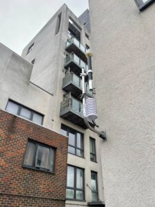
Specifically, I am designing lightweight and self-managing Internet of Things (IoT) devices to sense real-time temperature across London and transmit the data using Long Range Wide Area Networks (Lora WAN). I am also visualising the data with various Geographical Information System (GIS) techniques to communicate the findings with a wide range of stakeholders. I am currently partnered on this project with the Greater London Authority.
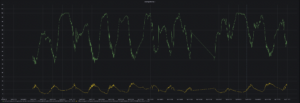
The long-term goal of my research project is to develop a “Microclimate Network” which will be capable of real-time air temperature monitoring across London at greater resolutions than what is currently available. This will be accomplished by both deploying sensor-based systems myself and facilitating the collection of crowdsourced data from citizen scientists. Through this comprehensive network, we aim to identify hotspots and cool zones in real-time.
I am comparing various visualisation tools such as dashboards, physical gauges, heat maps and 3D maps to aid the communication of this complex information.
The results of this research will be valuable to climate planning initiatives across London, specifically in helping policymakers manage and mitigate urban heat island effects within the city.
References: